

Hurricane Isaias Could Bring Heavy Rain and Strong Winds to East Tennessee Saturday |
Rain bands, strong mountain winds and gusty valley conditions are possible as the remnants of Isaias move inland this weekend. |
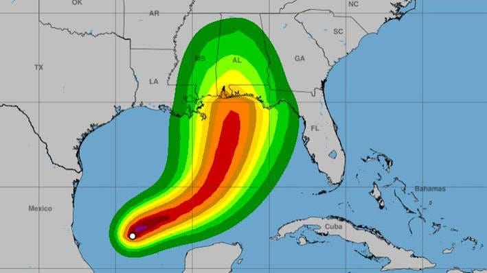
East Tennessee is expected to stay relatively quiet through Friday, but the weekend could look very different as Hurricane Isaias moves inland from the Gulf Coast.
Current forecasts call for bands of rain to reach the region Saturday, along with strong winds — especially in the mountains and foothills.
For most of East Tennessee, this does not appear to be a hurricane-impact scenario. Instead, the main concerns are heavy rain in spots, strong gusts, downed branches and trees, and difficult travel in exposed mountain areas.
Saturday is the main weather day
The first rain bands are expected to move into East Tennessee on Saturday, with the Cumberland Plateau likely to see some of the heaviest rainfall.
Rain is expected to arrive in bands rather than as one continuous all-day downpour, but locally heavy pockets are possible.
At this point, widespread flooding does not appear to be the primary threat for most of the 865 area, though low-lying and poor-drainage locations could still see temporary problems.
Mountain winds could be the biggest concern
The strongest local impact may be wind.
Forecasts show the potential for mountain and foothill gusts exceeding 60 mph Saturday as the pressure gradient tightens across the region.
That could create hazardous conditions along exposed ridges and mountain roads and may bring down tree limbs or weakened trees. Hikers, campers and anyone planning time in the Smokies should pay close attention to updated forecasts before heading out.
Knoxville and the valleys could also get gusty
Away from the mountains, East Tennessee could see sustained winds around 15 to 30 mph, with gusts approaching 45 mph by Saturday evening and Saturday night.
Those winds may be enough to knock down small limbs, move unsecured outdoor items and cause scattered power outages. If you have patio furniture, decorations, umbrellas or other lightweight items outdoors, Friday is a good time to secure them.
Severe weather risk appears low, but not zero
There is also a low risk for a brief tornado, mainly across the Cumberland Plateau Saturday evening or Saturday night. That threat is limited for now, but it is another reason to keep weather alerts turned on through the weekend.
Conditions can change quickly as tropical systems move inland, especially if the storm track shifts.
Sunday should gradually improve
Some showers may linger into Sunday morning, and breezy conditions could continue through the day.
Rain chances are expected to decrease later Sunday, but gusty winds may hang around even after the heaviest rain moves out.
What to do before the weekend
If you have outdoor plans Saturday, build in some flexibility. Check the forecast again before leaving home, especially if you are heading toward the Smokies, Cumberland Plateau or other higher-elevation areas.
It is also a good idea to charge phones, secure loose outdoor items and make sure you have a way to receive weather alerts overnight.
The main takeaway for East Tennessee is straightforward: Saturday could bring a noticeable round of tropical rain and wind, with the mountains facing the strongest gusts.
Because Isaias is still moving toward the Gulf Coast, the exact track and local impacts can still change. A fresh forecast check Friday morning will be important before making final weekend plans. |
0 Comments
Join the conversation
Be the first to comment
Share your thoughts above.